Getting Started
PTV Vistro eliminates the frustrations of defining map regions, tiling, and model scaling. Our network objects are automatically given real-world coordinates and drawn to the correct scale; thus, making seamless transitions to PTV Visum and Vissim.
Hello, World Welcome to PTV Vistro!
Welcome to PTV Vistro! Immediately, when opening a new PTV Vistro project, you are taken to the BingTM aerial and road hybrid web-based map that is ready for you to zoom into your project location anywhere in the world. You are also greeted by the Vistro start page, which provides up-to-date release and service pack information and videos in PTV Vistro Training Web Series.
Furthermore, PTV Vistro’s sleek modern Graphical User Interface (GUI) is planned out for your optimal performance. Vistro’s GUI is thoughtfully loaded with helpful icons and features that provide you with an intuitive workflow, guiding you through your traffic optimization project or impact study. Episode 2: Part I and II of the PTV Vistro Training Web Series, discusses Vistro’s GUI in detail.

Power of Mapping
Using Vistro’s strong web maps provides you with an optimal Quick Start experience. There’s no need to fumble with map regions, importing tiles into a background menu, and then picking random scale points within the model. Vistro’s objects are automatically scaled to the web background. Why? Because Vistro’s primary web-based mapping tools use real X, Y world coordinates, and not some arbitrary location with scale linking the map to model.
For example, the Telescope Dome at the Greenwich Park Royal Observatory in southeast London lies about 255 feet (78 meters) due west of the Prime Meridian. In Vistro, if you zoom to this point, your X-coordinate will go to 0.
Thanks to real-world coordinates established by the Sphere Mercator Web projection (ESRI:53004), you can seamlessly import your Vistro network to and from PTV Visum and to PTV Vissim to the exact web map location, making it easy for you to complete all or part of your model in Vistro, and then import your network into PTV Vision Suite products.
Working with coordinates
More map possibilities
In addition to Bing’s three map types: hybrid, aerial, and road, PTV Vistro also provides you with OpenStreetMap (OSM). Areas with detailed OSM data sets can give you direct access to extra information about your project area, such as traffic signal locations, building address numbers, names, and categories, transit, and parking information, and jurisdictional boundaries. To take full advantage of OSM opportunities and learn how to jumpstart your PTV Vistro model with OSM data, which can be a critical shortcut for larger models that are starting from scratch.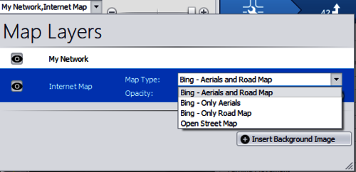
PTV Vistro provides, Bing aerials and road maps, and OpenStreetMap.
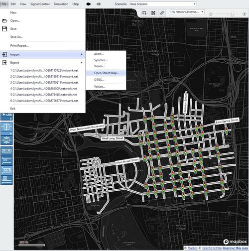
PTV Vistro's OpenStreenMap Import.
Add extra images to decorate your network
Of course, PTV Vistro still provides you the standard option to import custom maps and images – and this experience is even enhanced, by being consistent, quick, and easy. Vistro’s image pick box grips allow you to dynamically drag and stretch images and show transparency while editing, letting you place your images exactly on top of the web map. And if your image absolutely needs the good-old scaling ruler, Vistro has one, and you to zoom into exact points, resulting in a precise scale. Image file types the those common in day-to-day business, such as: .sid; .tif; .dwg; .dxf; .bmp; .png; and .jpg, and then some more, such as: jp2; .svg; .gif; and .ecw.
To spice up your Vistro model, you can insert file types that support alpha-channel background transparency, such as .png and .emf. And, you can order these images from top to bottom. This will help you define project boundaries, proposed development areas, add sign graphics, or annotate in your model.
Taking a simple screen captures of your network and pasting it into PowerPoint will allow you to trace shapes, with or without fills, over the map. Then in PowerPoint, you can right-click on the shape, save the image as one of these transparent file types, and insert the background into Vistro.
Coordinate with PTV Vistro
PTV Vistro’s Quick Start experience allows you to efficiently build your model. The benefits of easy web-mapping features help you place your model at real-world coordinates. Real Coordinates enables you to take your PTV Vistro model across multiple PTV Vision Suite products for a full multiresolution experience. And this enables Vistro to be used as a Quick Coder to develop the building blocks of a model in PTV Vissim or Visum. By adding extra background images to a Vistro model, you can professionally decorate your network to effectively conduct or communicate your project.